NASA Hackathon Space Apps Challenge
Water Explorer
Water Explorer aims to connect communities to local water bodies and aquatic endangered species. We aim to design an interactive platform that informs users of their surrounding waterbodies that accommodates various knowledge levels.

There are limited ways for people to access information about the local water ecosystem, its species and how to preserve them in a simple and engaging way.
Create an app to inform about endangered species, preservation methods and usage tips for nearby bodies of water.
OCT 1-2, 2023
Team Lead
Design Thinking
Wireframing
Protoyping
Figma
Miro
Slack
UI/UX designers
Front-end Developers
Our Goal
Through this project, the team seeks to develop connections between communities and their local water bodies, recognizing them as vital resources that sustain life and ecosystems. With the goal of translating quantified data from NASA and partner agencies to a readable and accessible format for people with various knowledge backgrounds, Water Explorer addresses the practical, logistical and ethical concerns of everyday users.
Research
Within a limited time, we first divided the work amongst the team on Miro to create a persona, conduct competitor analysis, search for available resources and build a design guide. Without primary research data, we’ve listed our potential users goals, behaviors, needs and pain points of several distinct personas through online searches. The research on brand guidelines provided a basis of required and nice-to-have features for the app, which were then organized into an information architecture. This process created the initial framework and boundary for our envisioned app.

Data Analysis
Focusing on data related to water quality and species at risk, we’ve decided to search for sources that provide precise locations globally which includes:
NASA’s Sea Surface Temperature (SST)
Ocean Microplastic Concentration
CSA’s Surface Water and Ocean Topography (SWOT)
Being mindful of the aims of accessibility and inclusivity, the concept for the app would be to display a curated set of current information based on the user’s location worldwide. Without prior expertise in data processing, our team conducted site-specific research for a sample bodies of water (Grenadier Pond in High Park, Toronto) to populate the prototype interface. Research was also conducted for Atlantic Cod, an endangered species (not local to the water body example) for sample information on the prototype.Water quality parameters reported in the app include:water temperaturepesticide levelheavy metal contentsalinitymicrobiological contaminationpH level
These are selected to reflect metrics outlined in the Guidelines for Canadian Recreational Water Quality. To ensure readability, the statistics are also visualized on linear scales which indicates the safe range of values for each parameter.
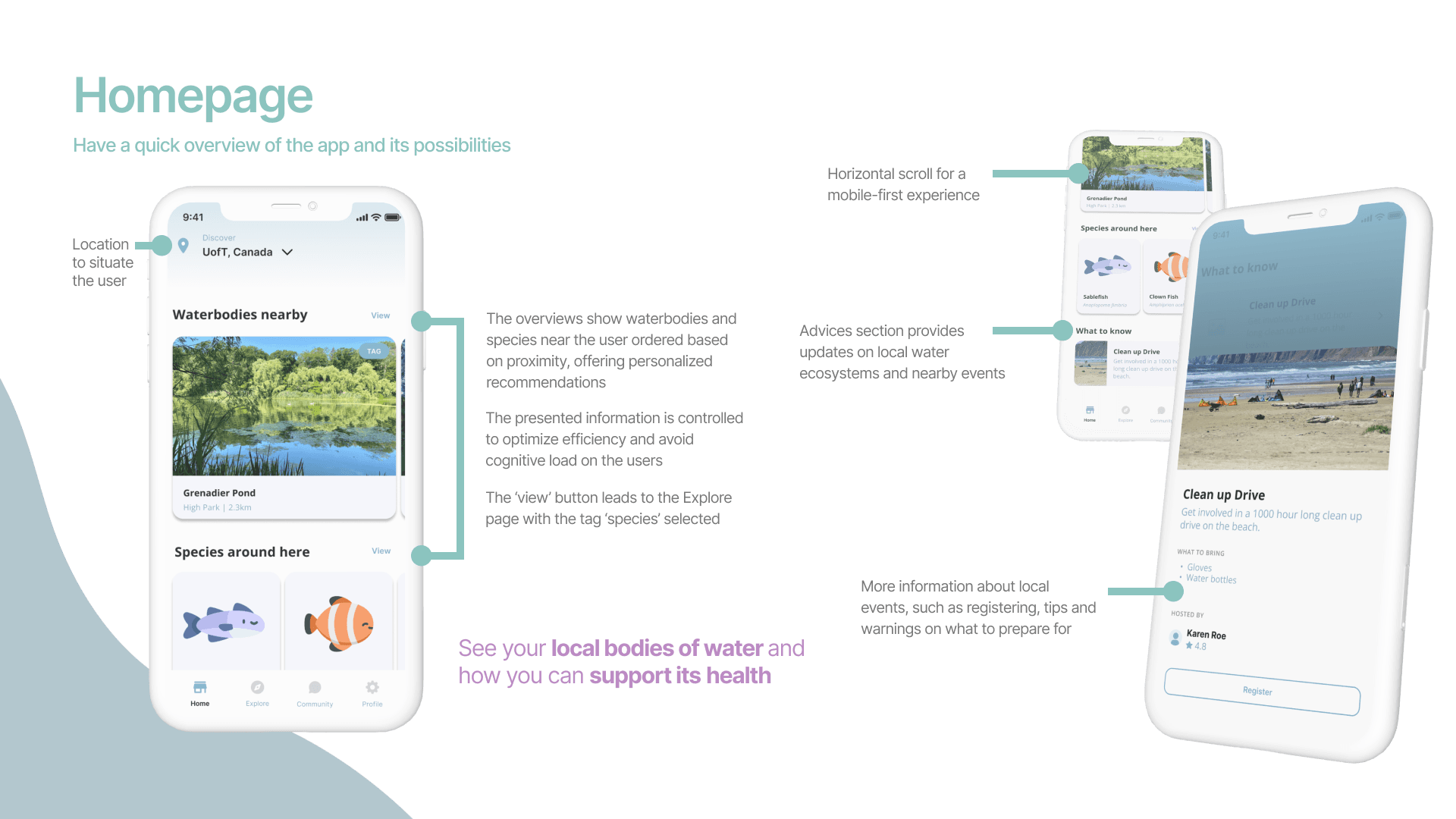
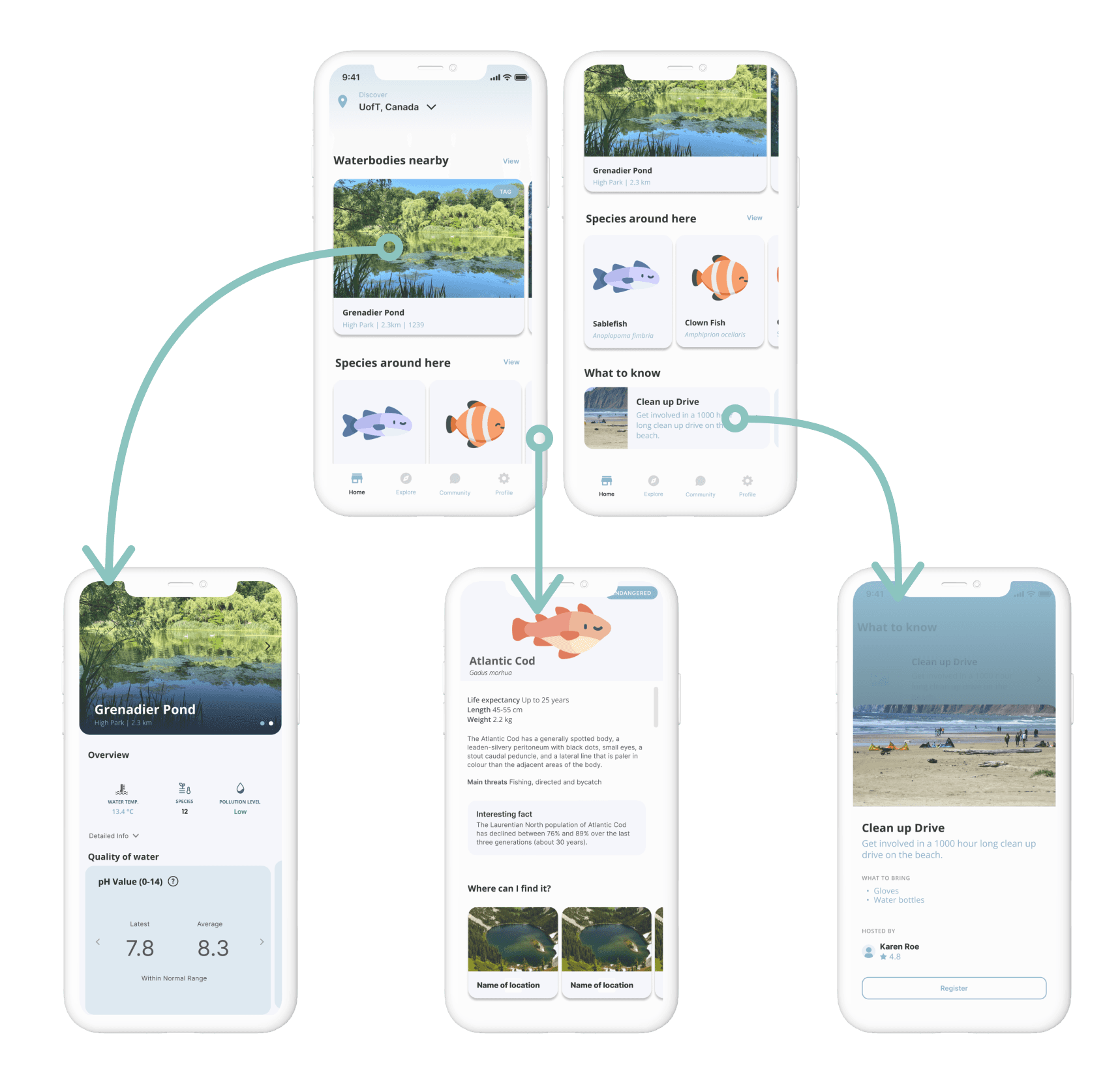
The home screen shows a personalized summary of nearby water bodies, local species, and upcoming environmental events in the area in the form of carousel menus to entice user interaction.
Carousel/horizontal scroll menus: allows for guided viewing and recommendations while offering user interaction and control
Each item in the menu is linked to the respective detailed information page.This feature enables a user who is on-the-go to quickly and easily obtain desired information.

The explore screen features an interactive map with location pins and a search bar. Swiping up the list overlay will expand the list to allow browsing with image previews of the water bodies, species or events. The different inventions are interconnected to help users easily relate and navigate between the different data presented.
To encourage community engagement in water preservation efforts, a community platform was designed. Users can share their sightings, water usage stories, and live water conditions with the nearby and global community. This feature addresses the lack of recent visual representations of water bodies and provides a means of positive feedback for users to encourage engagement.

In the details page for a body of water, an overview of water quality (water temperature and pollution level) and local species is provided. The numerical data means are presented with icons and colorful cues to increase readability. Other features include:
An accordion that offers further details on pesticide level, heavy metal content, salinity, microbiological contamination and pH level, which feed into the overall “pollution level” metric as justified by the Guidelines for Canadian Recreational Water Quality
A breakdown of current versus average water temperature, pH, and alkalinity of the water is presented in a horizontal scroll menu, and tips on how the user can make use of the information are offered upon clicking on each box
The journey of water section fulfills the user’s curiosity and gives them an idea of where the water they are visiting originates from
Reflection
This intensive two-days design challenge has helped me develop skills for leadership, communication and working under a tight deadline. Going through the design and implementation process in just two days, it was a valuable experience for me to understand the importance of the different iterative stages of app development. It was also fascinating and inspiring to see how we actualized ideas into visual representations and ultimately a mockup web display.